(Disclosure: Summit Land Management is a Rose Law Group-related company and contracted with the firm.)
By Paul Basha, Kayla Amado | Rose Law Group Reporter
It is excessive, current traffic is only 17% of capacity. Once upon a time, it was intended to be full of cars by now. It was planned to be Goldilocks: not-too-big-not-too-small.
As John Steinbeck wrote, “the best laid plans of mice and men often go awry”.
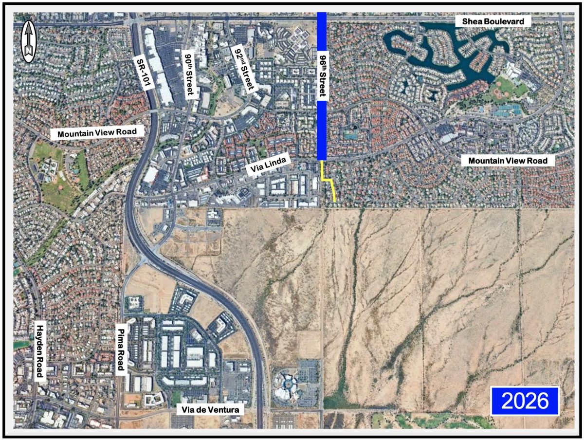
Below is a current aerial photograph indicating the portion of 96th Street your question references, plus the portion of 96th Street, south of Via Linda.
Below is an aerial photograph from 1997 – a few years before the Pima Freeway was constructed in this part of Scottsdale, and a few years after the Pima Freeway was opened a few miles south of this area.
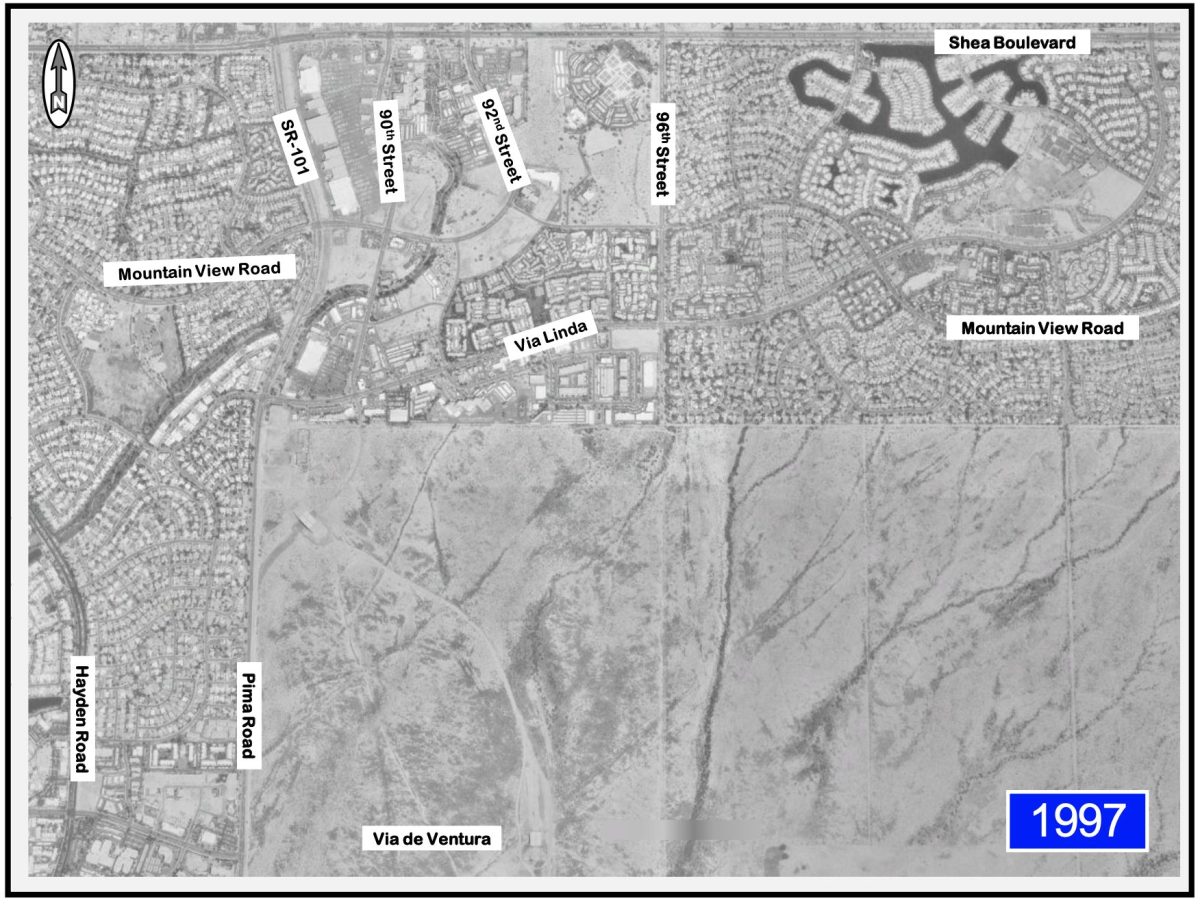
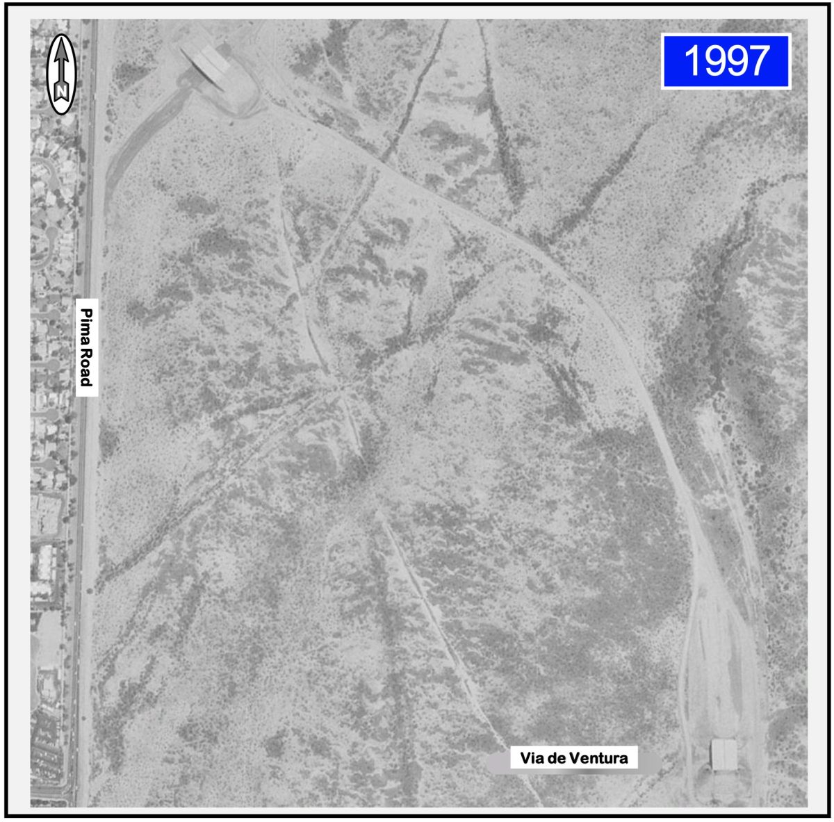
Those with keen eyesight, and those who were around these parts back then, notice two subtle rectangles in the desert in the photograph above.
The enlargement below of that area with the two little boxes, is more revealing. The little box in the upper left and the little box in the lower right are now freeway interchange bridges. Five freeway interchange bridges were constructed a few years before the freeway was constructed between the bridges. The bridges were over Indian School Road, Chaparral Road, McDonald Drive, Indian Bend Road, Via de Ventura, and 90th Street. We had the bridges to nowhere long before Alaska. We did make the national press with these great unconnected bridges over, and completely surrounded by, … empty desert.
Yep, people were encouraging the Arizona Department of Transportation (ADOT) to hurry up and build the Pima Freeway. Unfortunately, there was quarreling about the exact alignment of the Pima Freeway. Freeway Action Now (FAN) wanted the freeway constructed quickly on the original Pima Road alignment. Save Our Scottsdale (SOS) wanted the freeway constructed one-quarter mile east of Pima Road. Both groups were City of Scottsdale residents who lived close to Pima Road. The Arizona Department of Transportation simply wanted to build the freeway.
Through conversations with these two resident groups, the City of Scottsdale, the Salt River Pima-Maricopa Indian Community, and the Arizona Department of Transportation; the now-existing alignment was selected.
It is essentially approximately one-quarter mile east of Pima Road from Rio Salado to the Arizona Canal. So, SOS won the quarrel … mostly.
There is a peculiar curve near Thomas Road, where the Pima Freeway comes much closer to Pima Road. The people who owned the land under the straight freeway alignment were friends with the leader of Freeway Action Now. So, spitefully, these people refused to grant the Arizona Department of Transportation the right to use their land for the Pima Freeway. So, the freeway curves around their property, to this day, and forever.
The Arizona Department of Transportation, attempting to be very responsive to people wanting the freeway to be built quickly, decided on the freeway alignment. The negotiations for acquiring permission for the land in the new alignment began. Plus, ADOT needed to sell the houses that were purchased immediately adjacent to the Pima Road alignment. They were able to quickly acquire the land for the interchanges – land adjacent to freeway interchanges is always
quite profitable, and therefore the land for interchanges is usually easy to acquire.
Simultaneously, ADOT negotiated with the City of Scottsdale and the Salt River Pima-Maricopa Indian Community about the status and ownership of Pima Road. The west half was in the City of Scottsdale and the east half was in the Salt River Pima-Maricopa Indian Community. The border between the city and the nation was and is the Pima Road centerline.
None of the three agencies wanted responsibility for maintaining or repairing that pavement. None wanted to paint the lane lines and pavement markings. None wanted to maintain, repair, or control the traffic signals. The Pima Freeway on the Salt River Pima-Maricopa Indian Community solved all transportation problems for all three agencies. Pima Road became unnecessary for everybody. So, those negotiations required much time. Oh, and the Freeway Action Now and Save Our Scottsdale people joined forces to pressure ADOT into designing and building a sound-prevention wall.
Children are not just little adults, though adults can certainly be big children.
Until the late 1990’s and early 2000’s; prior to the advent of SR-101, SR-202, and US-60; ADOT was generally a rural interstate freeway agency. Their land purchase expertise was with owners of very large land areas with very few buildings. The Pima Freeway negotiations required them to gain expertise acquiring property from numerous owners of small land parcels with houses and other buildings. That learning process was not immediate, though definitely was successfully achieved.
So, while the land acquisition and Pima Road status negotiation ensued, ADOT kept busy finishing the design of the freeway interchange bridges, and then completed the construction. ADOT risked that their designated freeway alignment, with the newly constructed bridges, would remain acceptable. Or perhaps, would encourage the quarreling to end?
Incidentally, all transportation planners and most traffic engineers do not live in the present, we live in the future, and quietly watch the rest of us slowly catch up.
That risk proved to be wise, though it left us with five freeway interchange bridges without a connecting freeway for a few years. People in all agencies were nervous.
Eventually all the negotiations were successful, and the connecting freeway was designed and constructed. (And then, from the complete Pima Freeway opening in 2000, through today, ADOT continues to widen and improve it, because traffic volumes render it very necessary to do so.)
All that quarreling between Freeway Action Now and Save Our Scottsdale resulted in the Salt River Pima-Maricopa Indian Community having developable land on both sides of the Pima Freeway, north of Indian Bend Road. Very good for them!
And all of that brings us back to 96th Street, south of Shea Boulevard. Though, not immediately. Some photographs, maps, landmarks, and esoteric history first.
North of the Arizona Canal, the Pima Freeway is one-half to three-quarter-mile east of Pima Road. North of the Salt River Pima-Maricopa Indian Community, the Pima Freeway is on the Pima Road alignment, until it curves west, approximately 5 miles north at Frank Lloyd Wright Boulevard.
In the curve from the east of Pima Road alignment to the Pima Road alignment, there is a wall on the west side. This wall includes an interesting and meaningful spiral. To the south, on Salt River Pima-Maricopa land, the wall is beige, and to the north, on City of Scottsdale land, the wall is gray.
On Salt River Pima-Maricopa land is the famous man-in-the-maze symbol, sacred to the Tohono O’odham and the Akimel O’odham (Pima). This represents the journey of life, its choices, and the search for balance. On City of Scottsdale land is a horse and a cowboy riding the horse, holding his hat in his hand.
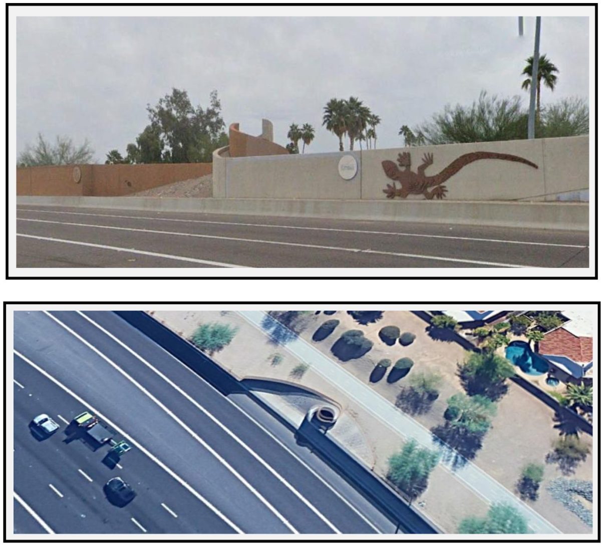
The central feature – the spiral – represents a thumb handshake between the two adjacent cultures. Oh, for those of you born this century, the thumb handshake pre-dated the fist bump. Some claim the thumb handshake originated by the two people slightly cutting the lower fleshy part of their thumbs, then mixing their blood – a blood oath of intense friendship and loyalty. The normal handshake is believed by many to be an historic symbol of “I have no weapon”. The handshake where each person grabs the forearm of the other was originally to ensure there was no short dagger hidden in the other’s sleeve. A fist bump means “I do not want your germs, but otherwise you’re ok”.
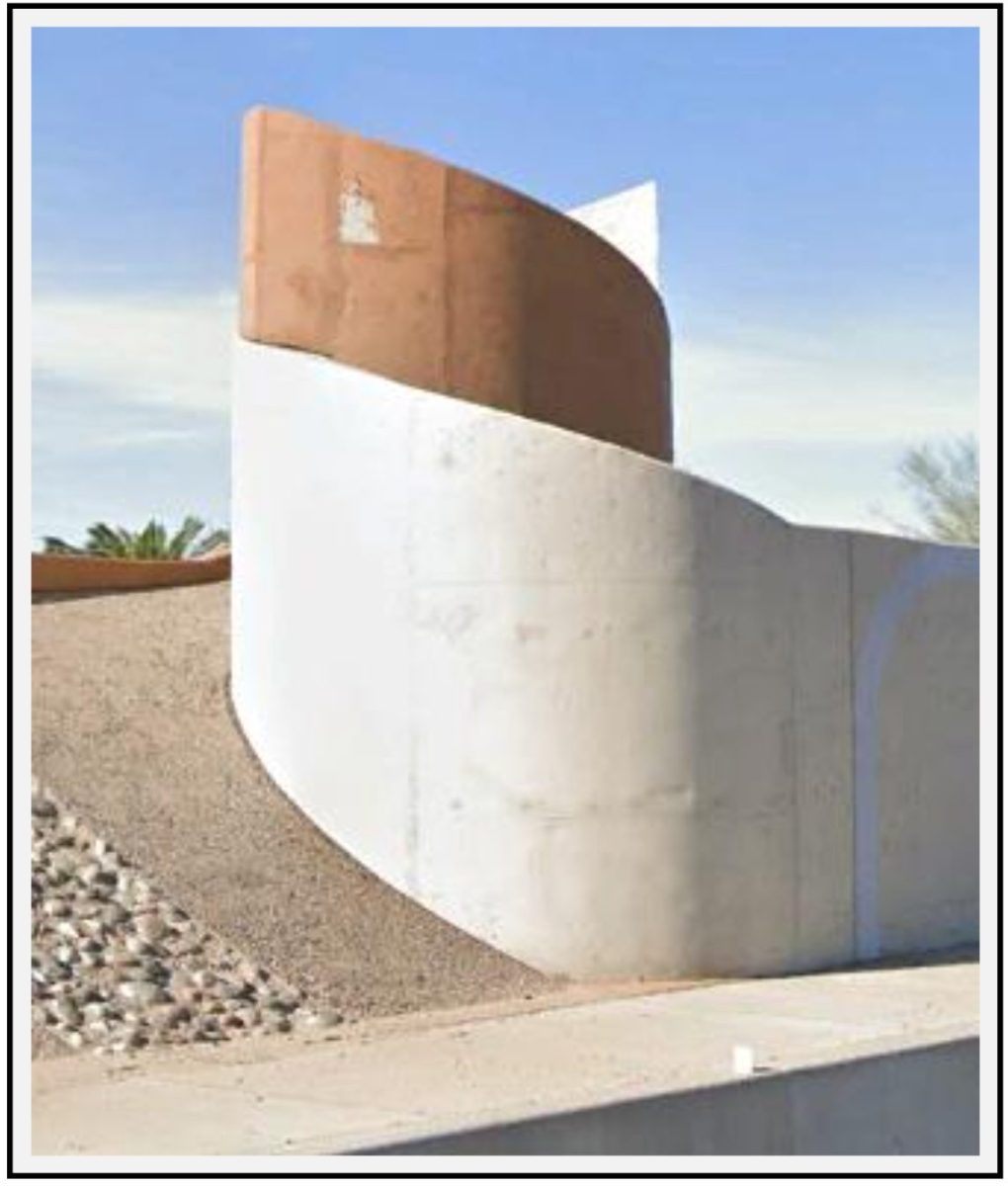
So, most cool! After the internal Scottsdale dissension and the much more friendly discussion between the City of Scottsdale and the Salt River Pima-Maricopa Indian Community, we have a rather permanent artistic expression of harmony between adjacent communities.
Incidentally, the Arizona Department of Transportation did not have to pay for the artistic features on the freeway walls within the City of Scottsdale. The City of Scottsdale paid that very high price. And we’re all very glad these sculptures are there!
Before all this freeway alignment turmoil, the City of Scottsdale had a street circulation plan within its General Plan (before the state required voter-approved General Plans). The earliest versions of these circulation plans did not include a freeway. The version developed in the late 1980’s included the Pima Freeway on Pima Road.
This plan had a hierarchy of streets from more lanes for more cars to fewer lanes for fewer cars. The freeway is at the top of the food chain, followed by six-lane-major arterials, then four-lane-minor arterials, then two-lane-minor collectors. (There was and is also a four-lane-major collector, though please allow me to try to focus on concepts, not esoteric traffic engineer jargon.)
Typically, the City of Scottsdale circulation plans, and those of most cities planned after the 1980’s, focus on a grid street system, with streets separated by one mile. You know, 56th Street, 64th Street, Scottsdale Road, Hayden Road, and Pima Road are each one mile (8 blocks) apart (mostly). As are McKellips Road (Van Buren Street), McDowell Road, Thomas Road, Indian School Road, Chaparral Road, McDonald Drive, and Indian Bend Road.
Seattle and Vancouver, British Columbia only dream of a grid system as mountains and water for some inexplicable reason, do not follow a grid pattern. Toronto has two kilometers in their grid system – so much better. Montreal and Quebec City; as well as Boston, New York City, Baltimore and other much older cities are completely a jumble without a grid system. Even Tucson has a one-mile grid.
Interestingly though, the mile did not become an international standard measurement unit until 1959.
“Mile” was first used by the Roman Empire meaning 1,000 paces. The Roman Empire also invented mileposts – a stone monument indicating the distance from the center of Rome. The British copied the Roman word mile, though every British town had their own definition of one mile. In 1593, the British decreed that one mile would be 5,280 feet throughout the British Empire. So, when America was colonized, the good loyal British subjects that we were (initially) used one mile as 5,280 feet.
Measurement changed with the French Revolution and their attachment to order and science. In 1795, they decreed the (very logical) metric system, where everything was multiples of 10 meters: millimeters, centimeters, kilometers, and myriameters. Evidently, myriameters was too difficult for the French to say; so instead of 10,000 meters; common use was 1,000 meters. No more inches, feet, miles, (or cubits)!
So, all was well throughout the world with everyone using the metric system, except US?
No.
Though many different countries still used the word mile, they defined a mile relative to the kilometer, or for some inexplicable reason, the yard. It seems that every country had their own definition of mile. The Irish said that one mile was 2,240 yards. The Ottomans said one mile was 1.89435 kilometers. In Portugal and Brazil, 2.0873 kilometers. Russia, 7.469 kilometers. The Scandinavians had no clue, with one part of Sweden saying one mile was 14.485 kilometers, and another part of Sweden saying one mile was 36,000 feet; and at least 7 other different definitions of mile in various parts of Scandinavia. That’s a fair bit of discrepancy!
In 1959, six English speaking countries decided that one mile would be 1,760 yards or 5,280 feet or 1.609344 kilometers. Most countries care nothing for the definition of mile, as they use the metric system. Canada converted to meters in 1977. Ireland converted in 2005. For us, for 67 years now, we have known the definition of a mile in inches, feet, and kilometers.
There is nothing in the constitution, or any other national document, that mandates arterial streets at one-mile separation throughout the United States. The genesis of the one-mile grid system is the process we use in the United States for determining land ownership parcels.
For some reason, the Public Land Survey System adopted by the United States Congress defined 640 acres as a one square mile section. People could easily sell their multiple sections of land in half-sections (320 acres) and quarter sections (160 acres). Eventually selling land in 40-acre, 10-acre, 5-acre, and even 1-acre plots, became common place. The defined standard of one-square-mile parcels created privately owned parcels. So, people owned property one mile wide in the north-south direction and one mile wide in the east-west directions.
While many people owned much more than 640 acres or one square mile, the edge of their property, wherever that was, was typically a section line. And somebody else owned the property on the other side of that section line. So, it became logical for the boundary between two properties to become a road. That way both property owners could access their property and no one section had to have all of a road within it. Except for those people who owned dozens or hundreds of sections. Though, even those people knew they would likely sell land by section, if they sold any land, so they were also comfortable with roads on section lines.
So, the Public Land Survey System adopted by the United States Congress in 1785 did not mandate a one-mile grid street system. Though it resulted in a land pattern that was easily accommodated by a one-mile grid street system. And by chance, such a grid-system has served us well.
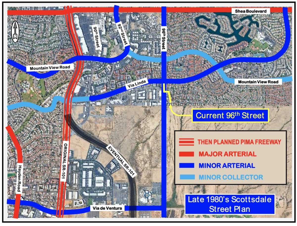
With a one-mile grid system, there are just the correct number of lanes to serve the businesses and residents. However, for decades, Scottsdale was part of the urban metropolitan area, while the Salt River Pima-Maricopa Indian Community was essentially rural. So that little blue and red street map above came to an abrupt edge. In the 1980’s and 1990’s, there was no grid street system within the Community, nor should there have been. Rural land does not need a well-developed system of streets. They have other priorities. So, Mountain View Road, 92nd Street, and Via Linda are jammed into a little area north and west of the Salt River Pima-Maricopa Indian Community. This weak substitute for a one-mile grid street system worked reasonably well, until the portion of Scottsdale to the north and east became a very desirable place to live, especially in the 1990’s and 2000’s, and more so, with the Pima Freeway.
Now, that our knowledge of Scottsdale, the Salt River Pima-Maricopa Indian Community, and measurements are all more complete, back to 96th Street.
Scottsdale transportation planners in the 1980’s knew the future. So, they did their best to plan the street system accordingly. When Scottsdale Ranch was first planned in the late 1970’s and early 1980’s, the City of Scottsdale added a north-south street one mile east of then Pima Road. They called this street 96th Street, being 96 blocks east of Central Avenue, (12th Mile would not have near the cache) and required the developer of Scottsdale Ranch to construct a four-lane, median roadway that would almost connect to the Salt River Pima-Maricopa Indian Community.
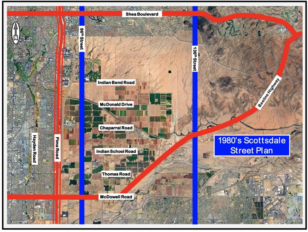
These transportation planners and traffic engineers knew that future commuting Scottsdale residents would need as much of a one-mile grid street system as could be developed. And they were hoping that the Salt River Pima-Maricopa Indian Community would agree. And also, so that the cities of Mesa and Scottsdale would be able to connect, to the benefit of both cities self-interest, and to provide an alternative to the single Shea Boulevard connection between Scottsdale and Fountain Hills, the foresightful Scottsdale planners added a four-lane-medianed street on 136th Street, five miles east of 96th Street.
So that little yellow line in the southwest corner of Scottdale Ranch on the first embedded street circulation map further above, was intended to be temporary. The Salt River Pima-Maricopa Indian Community sometimes agreed with 96th Street through their community one mile east of Pima Road, and sometimes disagreed with it. Newly elected political leaders often have different opinions than previously elected political leaders. As the land east and west of the Pima Freeway, north of Indian Bend Road, developed into lucrative businesses, the Salt River Pima-Maricopa Indian Community recognized the benefit of 96th Street.
While the Scottsdale transportation planners and traffic engineers, in the 1990’s, were very much in favor of building the streets included in the 1980’s circulation plans, particularly 96th Street; certain residents of Scottsdale Ranch were not as favorably disposed. In 1998, the Scottsdale City Council abandoned the portion of 96th Street from Mission Lane to the Scottsdale border with the Salt River Pima-Maricopa Indian Community. This public action eliminated the possibility of 96th Street connecting Shea Boulevard into the Salt River Pima-Maricopa Indian Community. Some of the Scottsdale Ranch residents rejoiced, though not all Scottsdale Ranch residents and businesses cheered, and not all Scottsdale residents and businesses were elated, as they have later discovered.
There was a very similar problem when the City of Scottsdale attempted to build the Thompson Peak Parkway over the Central Arizona Project Canal in the late 1990’s. That connection brought tens of thousands of daily cars from north of the Canal through previously low-traffic neighborhoods south of the Canal. The residents south of the Canal sued the City of Scottsdale to prevent the connection of their six-lane street that stopped at the Canal to the four-lane street north of the Canal. That issue went to a hotly contested mediation between city residents and the City of Scottsdale, though the bridge was obviously built. Can you imagine the traffic on the Pima Freeway if Thompson Peak Parkway a mile and a quarter east had not been constructed?
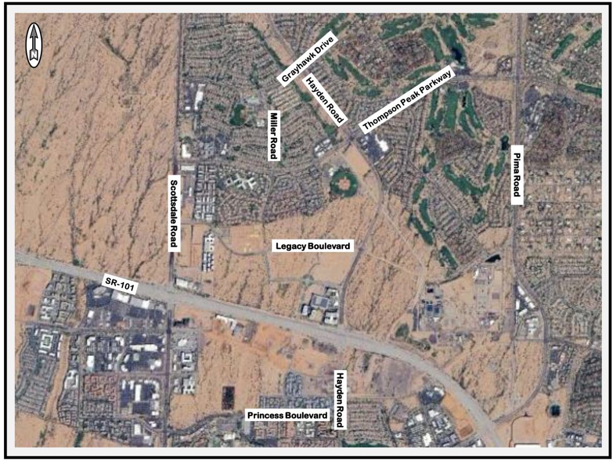
There is a current similar problem with the City of Scottdale trying to build Miller Road, south of Thompson Peak Parkway, so that Miller Road can connect Grayhawk Drive, crossing under the freeway, to Princess Boulevard. This will provide a third north-south street one-half mile between Scottsdale Road and Hayden Road, for only two miles. This road under the Pima Freeway, without an interchange, will substantially reduce current and future congestion on Scottsdale Road, and future congestion on Hayden Road, at the Pima Freeway. Though the people who live near the existing Miller Road are opposed to that Miller Road two-mile connection.
A quite similar exists with the reversible lanes of 7th Street and 7th Avenue in Phoenix. The residents near 7th Street, north of Dunlap Avenue, and the residents near 7th Avenue, north of Northern Avenue; are rather attached to the reversible lanes. Their commute is so much easier. However, those Phoenix residents who live and work near the reversible lanes of 7th Street and 7th Avenue; are most irritated by the reversible lanes and would very much prefer that they go away.
Same with speed limits on collector and residential roads near arterial streets. The people who live close to the arterial street greatly desire lower speed limits. The people who live further away from the arterial streets greatly desire high speeds. These further-away people feel strongly that the people who live in the closer-to-the-arterial homes that the further-away people drive by fast, should have been smarter when they bought their homes. (A former Scottsdale Councilmember, before they were elected, once told me that specifically and directly a few decades ago.)
Not a lot of blood-oath-thumb style handshakes between these various groups of two. More likely the forearm-check-for-dagger style handshakes.
Certainly can sympathize with the people who purchased homes near 96th Street, south of Via Linda. Their homes are currently at the end of a small residential community. If 96th Street were to be constructed now, where planned decades ago, they would suddenly live in a very different community as their homes would be adjacent to tens of thousands of daily vehicles, on four lanes, traveling at 45 miles-per-hour. Quite the lifestyle and rule change.
The difficulty of not having 96th Street connecting Shea Boulevard to Via de Ventura or McDowell Road or the streets in between, is clearly evident to anyone who lives further north or east in Scottdale Ranch or lives in Stonegate or Ancala or points further north and east, or anyone who drives Shea Boulevard at the Pima Freeway or drives Via Linda at 90th Street. These commuters have very few travel choices, because of the lack of a grid street system. These two intersections are among the most congested in Scottsdale, primarily because of the absence of a grid street system that 96th Street, south of Via Linda, would provide.
Remember that 96th Street, south of Shea Boulevard, is only at 17% of capacity? Well, Shea Boulevard, east of the Pima Freeway, is at 132% of capacity. If only those excess cars on Shea could use 96th.
The difficulty of not having the 136th Street connection between Shea Boulevard and east-west streets to the south, is also obvious to anyone traveling on Shea when the street is blocked by a traffic accident or construction or maintenance or something.
Please do not travel on Shea Boulevard between 96th Street and Hayden Road. Please use Mountain View Road – noticeably less traffic. If you need to access the Pima Freeway, use Cactus Road, even if you’re traveling south. Mountain View Road is 17% to 29% of capacity between Scottsdale Road and 92nd Street.
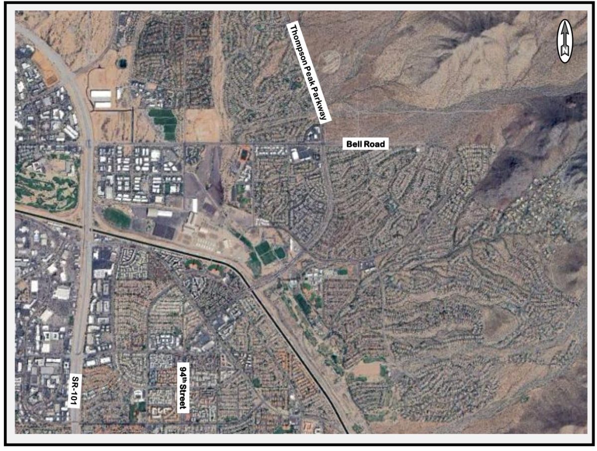
And, for north-south travel in this part of Scottsdale, please use 92nd Street to 94th Street to Thompson Peak Parkway. It is a short seven miles from Mountain View Road to the east-west portion of Thompson Peak Parkway. If you need the Pima Freeway, you can use Thompson Peak Parkway to Hayden Road to its interchange. Thompson Peak Parkway at the Central Arizona Project Canal is at 78% of capacity, though 26% to 38% of capacity for the remainder of its length.
Often the best route is a longer distance and shorter time, as we all have learned from artificially intelligent routing.
Once the one-mile-grid-street system is missing a street; somewhere closeby; there are too many cars on the remaining streets for all the people who want to live and drive in that greater area. But only for forever.
Curious about something traffic? Call or e-mail Paul at (480) 505-3931 and pbasha@summitlandmgmt.com.